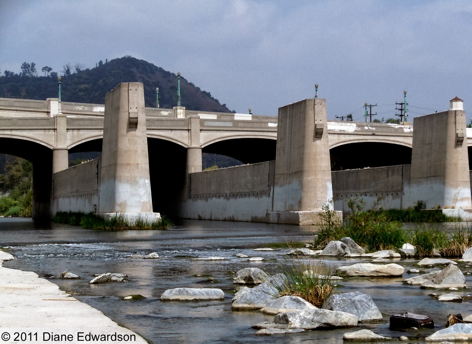
Photo: Joan Stevenson, January 31, 2016. There's still a lot of arundo in the LA River at the historic landmark Fletcher Bridge. Photos shot from the southwest corner of Fletcher and Ripple at Moore Street.
The Army Corps of Engineers is installing temporary flood barriers and removing vegetation from the riverbed from Griffith Park to the Fletcher Bridge.
Photo: Joan Stevenson, January 31, 2016. The high water mark for yesterday's rain was not so high, which is not so bad. The river path is always closed on rain days and it is closed between Griffith Park and Fletcher while the barriers are in place.
We're tracking rainfall totals in the Corralitas rain gauge...
January 31, 2016: 0.5"
Rain year* to date: 5.62"
*Normally, the "rain year" would have ended June 30. However, this year California joined the rest of the country, and will report rainfall totals between October 1 to September 30.
Who expected to have significant rain between July 1 and October 1?
There will always be an asterisk next to the 2014-2015 rain year on Corralitas Drive, which ended with 15.17." We got an unprecedented 4" between July 1 and September 30.
Showing posts sorted by date for query Fletcher Bridge. Sort by relevance Show all posts
Monday, February 1, 2016
Saturday, November 28, 2015
LA River To The Red Car Property: Get Up Early & Enjoy The Light
Photo: Jonathan Vandiveer, November 2015. The weather is perfect for a LA River walk. Seen here is the Atwater side of the LA River between Glendale Blvd and Fletcher. (Click on photos to enlarge.)
Photo: Jonathan Vandiveer, November, 2015. The Fletcher Bridge over the LA River is a City of Los Angeles Cultural Historic Landmark.
Photo: Jonathan Vandiveer, October 2015. The Pacific Electric Red Car Viaduct Footings are a City of Los Angeles Cultural Historic Landmark. They're two blocks from the LA River on Fletcher.
Photo: Jonathan Vandiveer, October 2015. The Red Car Property is not a park, it just looks like one. The trail from the viaduct footings goes a mile to the 2 Freeway and Corralitas Drive and further south along Corralitas Walk to Lake View Ave and Allesandro Way and the Holyland Exhibition.
Note: Kotolo Milkweed is a native plant in the foreground of the last photo. Its growing season is as screwed up as all the other plants this year.
Photo: Jonathan Vandiveer, November, 2015. The Fletcher Bridge over the LA River is a City of Los Angeles Cultural Historic Landmark.
Photo: Jonathan Vandiveer, October 2015. The Pacific Electric Red Car Viaduct Footings are a City of Los Angeles Cultural Historic Landmark. They're two blocks from the LA River on Fletcher.
Photo: Jonathan Vandiveer, October 2015. The Red Car Property is not a park, it just looks like one. The trail from the viaduct footings goes a mile to the 2 Freeway and Corralitas Drive and further south along Corralitas Walk to Lake View Ave and Allesandro Way and the Holyland Exhibition.
Note: Kotolo Milkweed is a native plant in the foreground of the last photo. Its growing season is as screwed up as all the other plants this year.
Labels:
Fletcher,
LA River,
native plants,
power line towers,
Riverside Drive,
Scenic Vista,
viaduct
Friday, November 27, 2015
Fletcher Drive & LA River: Looks Like Fall
Photo: Jonathan Vandiveer, November 22, 2015. The native Sycamore trees are dropping their leaves for fall along Fletcher Drive between the Red Car Property and the LA River. (Click on photos to enlarge.)
Photo: Jonathan Vandiveer, November 22, 2015. The Fletcher Bridge over the LA River is a City of Los Angeles Historic Landmark. You can access the river trail on either side of the bridge. If you're on foot or have dogs on-leash, the Atwater side is less crowded, as the path is not as bike friendly.
Labels:
Atwater,
DWP,
Elysian Valley,
Fletcher,
LA River,
native plants,
power line towers,
trees
Friday, June 19, 2015
Historic Pacific Electric Viaduct: 60 Years Ago Today, End Of The Glendale Line

Photo: Loren Ayers, June 19, 1955. The Ayers family rode the Big Red Car Trolley across the Fletcher Viaduct on the last day of service in 1955. (Click on photo to enlarge.)
The Glendale Line opened in 1905 as an all wooden trestle bridge. In 1927. the center section was replaced with steel to accommodate the paving of Fletcher.
Photo: Diane Edwardson, October 2004. In 2003, the City declared the Pacific Electric Viaduct Footings at Fletcher, cultural historic landmark #770. (Click on photo to enlarge.)Friday, February 6, 2015
Historic Viaduct Footings: Silver Lake's Stonehenge"
*This post was originally published January 18, 2007. Links to later posts have since been added.

Ever wonder what those concrete blocks are on the hillside above the Arco Station at Riverside and Fletcher Drives in Silver Lake? Hope Urban, who grew up in the neighborhood, calls them “Silver Lake’s Stonehenge.”
What are those concrete blocks? Who put them there? What purpose did they serve? While many neighbors think of them as gravestones of failed Red Car Property developers, they’re actually a piece of Los Angeles History.
While the Fletcher Red Car Viaduct no longer exists, its concrete foundations stood silent vigil to the changing attitudes toward public transportation in 20th Century Los Angeles.
The Pacific Electric “Big Red Car” trolleys were a hugely popular means of transportation for Los Angeles, particularly among the neighborhoods on the Edendale and Glendale lines.
In 1904, L.C. Brand & Assoc. constructed the Fletcher Viaduct for Los Angeles & Glendale Electric Railway, then sold the Glendale Line to Pacific Electric in 1906.
The viaduct, or bridge, was huge: 453’6” long, and 40’9” high, of wood trestle construction. In 1927, a 97’ center section of the viaduct was replaced with steel, accommodating the paving of Fletcher Drive. Fletcher was also lowered; the viaduct then stood 61’ above the roadway.
The Pacific Electric Red Car created the horizontal development pattern for Los Angeles – the sprawl we have today. Everywhere a Red Car Line was planned, real estate speculators followed.
Locally, the Glendale and Edendale Lines brought settlement to the Ivanhoe Hills. Our Silver Lake neighborhood reflects the typical development pattern surrounding Red Car Lines. In the early part of the century, as soon as new Red Car lines were planned, real estate speculators bought up the land immediately adjacent to the tracks; carved it into tiny lots; sold the lots to working families to build their own homes.
Riverside Place is one such street where it’s not unusual to find 500 sq. ft. homes on 800 sq. ft. lots. Moving further out from the tracks, homes and lots get larger. The ensuing socio-economic diversity still surrounds the Red Car Property in Silver Lake today. Most neighborhoods adjacent to Red Car Lines were bulldozed for freeway construction. Thus, making our neighborhood unique.
Homes and neighborhoods were built with easy access to the Red Car stops, with public stairways and walkways instead of streets. In 1955, the Glendale Line was decommissioned and the tracks removed in favor of freeway construction. [The viaduct was dismantled in 1959, along with the viaducts at Riverside and Glendale Blvd.] Neighbors on Riverside Place voted to give up 10’ of their front yards so the City could pave the street to their homes. Today, many of those homes have no setbacks or driveways.
The Red Car Viaduct Footings are symbolic of changing attitudes toward public transportation in 20th Century Los Angeles. First, Southern Californians embraced the Red Car as an economical, efficient and popular means of public transportation. Mid-century, the Red Cars were forgotten in favor of automobiles and freeways. Late in the 20th Century, Southern Californians rediscovered the Red Car, studying a successful model of public transportation.
The Fletcher Red Car Viaduct Footings are more than just the foundation for a Pacific Electric bridge. The concrete blocks are a foundation for not only Los Angeles, but also the region. Settlers, real estate speculators and population growth followed the Red Car Lines, wherever they went.
In 2003, the Los Angeles City Council confirmed the action of the Cultural Heritage Commission, declaring the Fletcher Red Car Trestle Footings as Historic-Cultural Monument #770.
As one neighbor put it, “It’s an oddly beautiful testament to our community’s past. It’s a quirky kind of landmark that fits Silver Lake.” The Red Car Viaduct Footings bring a unique identity to our neighborhood.

Ever wonder what those concrete blocks are on the hillside above the Arco Station at Riverside and Fletcher Drives in Silver Lake? Hope Urban, who grew up in the neighborhood, calls them “Silver Lake’s Stonehenge.”
What are those concrete blocks? Who put them there? What purpose did they serve? While many neighbors think of them as gravestones of failed Red Car Property developers, they’re actually a piece of Los Angeles History.
While the Fletcher Red Car Viaduct no longer exists, its concrete foundations stood silent vigil to the changing attitudes toward public transportation in 20th Century Los Angeles.
The Pacific Electric “Big Red Car” trolleys were a hugely popular means of transportation for Los Angeles, particularly among the neighborhoods on the Edendale and Glendale lines.
In 1904, L.C. Brand & Assoc. constructed the Fletcher Viaduct for Los Angeles & Glendale Electric Railway, then sold the Glendale Line to Pacific Electric in 1906.
The viaduct, or bridge, was huge: 453’6” long, and 40’9” high, of wood trestle construction. In 1927, a 97’ center section of the viaduct was replaced with steel, accommodating the paving of Fletcher Drive. Fletcher was also lowered; the viaduct then stood 61’ above the roadway.
The Pacific Electric Red Car created the horizontal development pattern for Los Angeles – the sprawl we have today. Everywhere a Red Car Line was planned, real estate speculators followed.
Locally, the Glendale and Edendale Lines brought settlement to the Ivanhoe Hills. Our Silver Lake neighborhood reflects the typical development pattern surrounding Red Car Lines. In the early part of the century, as soon as new Red Car lines were planned, real estate speculators bought up the land immediately adjacent to the tracks; carved it into tiny lots; sold the lots to working families to build their own homes.
Riverside Place is one such street where it’s not unusual to find 500 sq. ft. homes on 800 sq. ft. lots. Moving further out from the tracks, homes and lots get larger. The ensuing socio-economic diversity still surrounds the Red Car Property in Silver Lake today. Most neighborhoods adjacent to Red Car Lines were bulldozed for freeway construction. Thus, making our neighborhood unique.
Homes and neighborhoods were built with easy access to the Red Car stops, with public stairways and walkways instead of streets. In 1955, the Glendale Line was decommissioned and the tracks removed in favor of freeway construction. [The viaduct was dismantled in 1959, along with the viaducts at Riverside and Glendale Blvd.] Neighbors on Riverside Place voted to give up 10’ of their front yards so the City could pave the street to their homes. Today, many of those homes have no setbacks or driveways.
The Red Car Viaduct Footings are symbolic of changing attitudes toward public transportation in 20th Century Los Angeles. First, Southern Californians embraced the Red Car as an economical, efficient and popular means of public transportation. Mid-century, the Red Cars were forgotten in favor of automobiles and freeways. Late in the 20th Century, Southern Californians rediscovered the Red Car, studying a successful model of public transportation.
The Fletcher Red Car Viaduct Footings are more than just the foundation for a Pacific Electric bridge. The concrete blocks are a foundation for not only Los Angeles, but also the region. Settlers, real estate speculators and population growth followed the Red Car Lines, wherever they went.
In 2003, the Los Angeles City Council confirmed the action of the Cultural Heritage Commission, declaring the Fletcher Red Car Trestle Footings as Historic-Cultural Monument #770.
As one neighbor put it, “It’s an oddly beautiful testament to our community’s past. It’s a quirky kind of landmark that fits Silver Lake.” The Red Car Viaduct Footings bring a unique identity to our neighborhood.
Thursday, February 5, 2015
SLNC History Collective: TONIGHT
Free Screening " Los Angeles The Early Days"
Photo: Clarence Inman Collection, undated, after 1927. The Pacific Electric Red Car Trolley Bridge at Fletcher Drive was all wood construction atop 5' concrete pylons that were not even anchored into the hillside. (Click on photo to enlarge.)
Learn more about the Red Car Property's run as a private right of way for the "Big Red Cars."
Thursday, February 5, 2015
Meeting starts at 6:30 PM
Screening: 6:50 PM
2411 Glendale Blvd
Los Angeles, CA 90039
Sunday, June 1, 2014
Historic Fletcher Viaduct: The Big Parade Will Walk Through History Today
The Big Parade, the ultimate urban hike, will have to cross Fletcher at street level but can marvel at how the bridge stood up to earthquakes and rainy seasons on such shallow concrete viaduct footings. City of Los Angeles Cultural Historic Landmark #770 as seen from the Waverly Public Staircase.
Follow The Big Parade on Twitter as they work their way toward Griffith Park Observatory on Day 2.
Wednesday, February 26, 2014
Historic Viaduct Footings: "Silver Lake's Stonehenge"*

Ever wonder what those concrete blocks are on the hillside above the Arco Station at Riverside and Fletcher Drives in Silver Lake? Hope Urban, who grew up in the neighborhood, calls them “Silver Lake’s Stonehenge.”
What are those concrete blocks? Who put them there? What purpose did they serve? While many neighbors think of them as gravestones of failed Red Car Property developers, they’re actually a piece of Los Angeles History.
While the Fletcher Red Car Viaduct no longer exists, its concrete foundations stood silent vigil to the changing attitudes toward public transportation in 20th Century Los Angeles.
The Pacific Electric “Big Red Car” trolleys were a hugely popular means of transportation for Los Angeles, particularly among the neighborhoods on the Edendale and Glendale lines.
In 1904, L.C. Brand & Assoc. constructed the Fletcher Viaduct for Los Angeles & Glendale Electric Railway, then sold the Glendale Line to Pacific Electric in 1906.
The viaduct, or bridge, was huge: 453’6” long, and 40’9” high, of wood trestle construction. In 1927, a 97’ center section of the viaduct was replaced with steel, accommodating the paving of Fletcher Drive. Fletcher was also lowered; the viaduct then stood 61’ above the roadway.
The Pacific Electric Red Car created the horizontal development pattern for Los Angeles – the sprawl we have today. Everywhere a Red Car Line was planned, real estate speculators followed.
Locally, the Glendale and Edendale Lines brought settlement to the Ivanhoe Hills. Our Silver Lake neighborhood reflects the typical development pattern surrounding Red Car Lines. In the early part of the century, as soon as new Red Car lines were planned, real estate speculators bought up the land immediately adjacent to the tracks; carved it into tiny lots; sold the lots to working families to build their own homes.
Riverside Place is one such street where it’s not unusual to find 500 sq. ft. homes on 800 sq. ft. lots. Moving further out from the tracks, homes and lots get larger. The ensuing socio-economic diversity still surrounds the Red Car Property in Silver Lake today. Most neighborhoods adjacent to Red Car Lines were bulldozed for freeway construction. Thus, making our neighborhood unique.
Homes and neighborhoods were built with easy access to the Red Car stops, with public stairways and walkways instead of streets. In 1955, the Glendale Line was decommissioned and the tracks removed in favor of freeway construction. [The viaduct was dismantled in 1959, along with the viaducts at Riverside and Glendale Blvd.] Neighbors on Riverside Place voted to give up 10’ of their front yards so the City could pave the street to their homes. Today, many of those homes have no setbacks or driveways.
The Red Car Viaduct Footings are symbolic of changing attitudes toward public transportation in 20th Century Los Angeles. First, Southern Californians embraced the Red Car as an economical, efficient and popular means of public transportation. Mid-century, the Red Cars were forgotten in favor of automobiles and freeways. Late in the 20th Century, Southern Californians rediscovered the Red Car, studying a successful model of public transportation.
The Fletcher Red Car Viaduct Footings are more than just the foundation for a Pacific Electric bridge. The concrete blocks are a foundation for not only Los Angeles, but also the region. Settlers, real estate speculators and population growth followed the Red Car Lines, wherever they went.
In 2003, the Los Angeles City Council confirmed the action of the Cultural Heritage Commission, declaring the Fletcher Red Car Trestle Footings as Historic-Cultural Monument #770.
As one neighbor put it, “It’s an oddly beautiful testament to our community’s past. It’s a quirky kind of landmark that fits Silver Lake.” The Red Car Viaduct Footings bring a unique identity to our neighborhood.
*This post was originally published January 18, 2007. Links to later posts have since been added.
Tuesday, September 24, 2013
Hyperion Bridge: Reusing Red Car Trolley Footings For New Pedestrian & Bike Bridge*
Photo: Diane Edwardson, April 23, 2011. One of the mitigations for the Hyperion Bridge reconstruction project is a reuse of the old Red Car Trolley bridge footings in the LA River for a new pedestrian & bike bridge. (Click on photos to enlarge.)
The Hyperion Bridge complex was built in 1928, before current earthquake standards. So it's a pretty fair guess that if they're retrofitting the Hyperion Bridge for earthquake safety, there's no way these footings would meet standards for a train bridge today. The last Red Car Trolley crossed the LA River on the Glendale Line, June 19, 1955.

Photo: Diane Edwardson, April 23, 2011.
There is currently no room for a bike path, nor a real safe sidewalk on the Hyperion Bridge, nor was it in the plans for the updated bridge. Thankfully, there was no appetite for a road diet to take away lanes of traffic from the bridge (it's been in the works for years). Yet, it is the only option many students have for walking between Marshall High School & Atwater. It's not a safe way to walk to and from school.
When City Councilmember Mitch O'Farrell was a deputy for (then) Councilmember Eric Garcetti, O'Farrell secured funds from CalTrans to build the pedestrian bike bridge on the Trolley footings. The funds can only be spent on this particular pedestrian bridge project.
We here at the Corralitas Red Car Blog support this low-impact reuse of an important historic resource.
This pedestrian/bike bridge should not be confused with the $6 million North Atwater Multi-Modal Bridge just approved last week by City Council. That one is privately funded & involves equestrian use too.
It should also not be confused with the historic landmark #770, Red Car Viaduct Footings on the Red Car Property at Fletcher & Riverside Drives.
There's a big public meeting Wednesday, September 25, 2013 about the Hyperion Bridge Project.
*Read more on the $50 million dollar Hyperion Bridge makeover: The Eastsider
The Hyperion Bridge complex was built in 1928, before current earthquake standards. So it's a pretty fair guess that if they're retrofitting the Hyperion Bridge for earthquake safety, there's no way these footings would meet standards for a train bridge today. The last Red Car Trolley crossed the LA River on the Glendale Line, June 19, 1955.

Photo: Diane Edwardson, April 23, 2011.
There is currently no room for a bike path, nor a real safe sidewalk on the Hyperion Bridge, nor was it in the plans for the updated bridge. Thankfully, there was no appetite for a road diet to take away lanes of traffic from the bridge (it's been in the works for years). Yet, it is the only option many students have for walking between Marshall High School & Atwater. It's not a safe way to walk to and from school.
When City Councilmember Mitch O'Farrell was a deputy for (then) Councilmember Eric Garcetti, O'Farrell secured funds from CalTrans to build the pedestrian bike bridge on the Trolley footings. The funds can only be spent on this particular pedestrian bridge project.
We here at the Corralitas Red Car Blog support this low-impact reuse of an important historic resource.
This pedestrian/bike bridge should not be confused with the $6 million North Atwater Multi-Modal Bridge just approved last week by City Council. That one is privately funded & involves equestrian use too.
It should also not be confused with the historic landmark #770, Red Car Viaduct Footings on the Red Car Property at Fletcher & Riverside Drives.
There's a big public meeting Wednesday, September 25, 2013 about the Hyperion Bridge Project.
*Read more on the $50 million dollar Hyperion Bridge makeover: The Eastsider
Friday, June 21, 2013
Historic Viaduct Footings: Tarantula Hawk - No, It's Not A Raptor, It's Much Scarier
Photo: Diane Edwardson, June 18, 2013. I encountered the scariest bug, EVER, on the Red Car Property, just above the historic landmark Pacific Electric Viaduct Footings. (Click on photos to enlarge.)
I was down on the ground shooting photos of some Kotolo Milkweed, when a gigantic 3" long black wasp-like bug with rust colored wings suddenly took off from the ground nearby. It scared the Hell out of me & my dog. It flew about a foot off the ground slowly, trailing its very long, substantial legs behind. It kept landing & crawling in & out of gopher holes. It seemed to stay for quite some time in a few of the holes.
Photo: Diane Edwardson, June 18, 2013. This is the photo the first photo was excerpted from. I didn't want to get to close to the scariest bug I'd ever seen.
Since I'd seen this bug once every few years in June, on the south end of the Red Car Property, I figured it was time for some research. I searched What's That Bug? for a giant black wasp, Los Angeles. The first post was a photo from Clare Marter Kenyon, a fellow community activist from Mt Washington. Voila - scary bug identified: Tarantula Hawk. It even involved Milkweed (which further reading revealed, these bugs, like so many others, can't resist).
I sent my encounter to What's That Bug? A quick reply came from Bugman: "Several years ago, Daniel saw one in the Los Angeles River bed between the Hyperion Avenue bridge and the Fletcher Avenue bridge, right below the area you mentioned. Just last month, Daniel saw a Tarantula Hawk prowling the grounds near the Municipal Art Gallery in Barnsdall Park. There are most likely Tarantula Hawks in Griffith Park as well."
A Tarantula Hawk is a large spider wasp that is definitely a tenacious predator that lays its eggs in spiders. The larvae develop inside the paralyzed spider. Check out a number of photos & accounts of spider wasps in action from around the world on What's That Bug?
I was down on the ground shooting photos of some Kotolo Milkweed, when a gigantic 3" long black wasp-like bug with rust colored wings suddenly took off from the ground nearby. It scared the Hell out of me & my dog. It flew about a foot off the ground slowly, trailing its very long, substantial legs behind. It kept landing & crawling in & out of gopher holes. It seemed to stay for quite some time in a few of the holes.
Photo: Diane Edwardson, June 18, 2013. This is the photo the first photo was excerpted from. I didn't want to get to close to the scariest bug I'd ever seen.
Since I'd seen this bug once every few years in June, on the south end of the Red Car Property, I figured it was time for some research. I searched What's That Bug? for a giant black wasp, Los Angeles. The first post was a photo from Clare Marter Kenyon, a fellow community activist from Mt Washington. Voila - scary bug identified: Tarantula Hawk. It even involved Milkweed (which further reading revealed, these bugs, like so many others, can't resist).
I sent my encounter to What's That Bug? A quick reply came from Bugman: "Several years ago, Daniel saw one in the Los Angeles River bed between the Hyperion Avenue bridge and the Fletcher Avenue bridge, right below the area you mentioned. Just last month, Daniel saw a Tarantula Hawk prowling the grounds near the Municipal Art Gallery in Barnsdall Park. There are most likely Tarantula Hawks in Griffith Park as well."
A Tarantula Hawk is a large spider wasp that is definitely a tenacious predator that lays its eggs in spiders. The larvae develop inside the paralyzed spider. Check out a number of photos & accounts of spider wasps in action from around the world on What's That Bug?
Labels:
Adelbert,
Bugs,
Fletcher,
native plants,
Riverside Drive,
Tarantula Hawk,
Unusual Bugs,
viaduct,
wasp,
wildlife
Thursday, May 9, 2013
LA River, Elysian Valley: Recreation Zone Rules - Bring Your Reading Glasses
Photo: Diane Edwardson, October 15, 2011. You won't be able to pull your boats out of the LA River on the Metrolink Railyard side of the river, just north of the Confluence. (Click on photo to enlarge.)
There are a lot of rules, directions & instructions involved with the LA River Recreation Zone pilot program approved by the City between the Fletcher Bridge & the Confluence (like, don't bring your dog within 5' of the flat part of the riverbed - guess that's sort of a half-assed compromise.)
Read more: Echo Park Patch
Link to Q&A, Recreation Zone Rules
There are a lot of rules, directions & instructions involved with the LA River Recreation Zone pilot program approved by the City between the Fletcher Bridge & the Confluence (like, don't bring your dog within 5' of the flat part of the riverbed - guess that's sort of a half-assed compromise.)
Read more: Echo Park Patch
Link to Q&A, Recreation Zone Rules
Labels:
dog ban,
Elysian Park,
Elysian Valley,
LA River,
Metrolink
Monday, February 25, 2013
LA River Recreational Zone (& River Channel Dog Ban) Back On City Council Agenda Today

Photo: Diane Edwardson. Under the proposed rules people will be allowed in the river channel but even on-leash dogs will be banned. On-leash dogs will only be allowed on the bike path. (Click on photo to enlarge.)
The LA City Council Ad-Hoc River Committee will hold a public hearing on the proposed rules and parameters for the LA River Recreational Zone pilot program this afternoon in City Hall.
According to Lupe Vela, senior staff for City Councilmember Ed Reyes, the recreational zone itself has been scaled back due to construction on the pedestrian/bike/equestrian bridge at Atwater Creek; retrofitting of the historic bridge on Fletcher Drive; construction of the new Riverside Drive Bridge crossing the river near the Confluence. However, the recreational zone seems to be moving forward quickly nonetheless.
PUBLIC HEARING TODAY
LA CIty Council Ad-Hoc River Committee
Monday February 25, 2013
3PM
LA City Hall
200 N. Spring St, Room 1060
Los Angeles, CA 90012
Photo: Diane Edwardson, 2010. Horses are considered livestock so they would not be included in the ban. Currently horses have a place they can cross in the river near Atwater Creek, near the site of this photo. It often looks as if the horses are walking on the water, as it is just a concrete berm just under the water.
Related: Dog Ban January 27, 2013
Labels:
Atwater Creek,
dog ban,
Domestica,
Elysian Valley,
LA River,
politicos,
SMMC
Sunday, January 27, 2013
LA River: Proposed Recreation Zone Will Ban Even On-Leash Dogs From River "Channel"
Photo: D. Hibbs.. Walking in the riverbed near Sunnynook Bridge. (Click on photos to enlarge.)
All dogs will be banned from the LA River channel as a part of the LA River Recreational Zone Pilot Program set for a public hearing Monday. The LA City Council Ad Hoc River Committee is looking to open the Glendale Narrows to recreational, non-motorized boating this summer.
Buried deep in the rules that will be posted in the river channel (year round) is the ban on dogs, even on-leash dogs. People will be allowed in the channel (no swimming, skateboarding or biking in the channel), but not dogs or other pets. The LA River channel is defined as the slopes below the bike path, going down to the river, the flat part in the riverbed and the river itself.
Photo: Diane Edwardson. Near Atwater Creek aka North Atwater Park.
North of Fletcher, there is ample room to walk down in the riverbed. It's quieter to walk in the riverbed because you're below the freeway noise. It's also a lot more interesting. It offers a view on wildlife that most people never realized is in their backyard.
Photo: Diane Edwardson. Near Newell Street, Elysian Valley, don't try this in the rain.
While the flat parts of the channel in Elysian Valley are not as wide, there are places to explore too. Require a maximum 6' leash (no expandable 20' leashes - to protect wildlife) and require picking up after your dogs. (I've encountered more human feces piles in the river than dog feces piles. The homeless still use the river storm drain outlets as a bathrooms.)
Photo: Diane Edwardson. The bike path in Elysian Valley is very narrow and soon will be your only option when you take your dog to the river.
Under the proposed soon-to-be-posted rules, on-leash dogs will only be allowed on the bike path between North Atwater Park and The Confluence. The bike path is not easy to walk with a dog. You're constantly looking over your shoulder because you can't hear bikes coming up from behind due to the noise of the 2 & 5 Freeways and the idling trains at the Metrolink Maintenance Yard. (If you think it's loud, imagine how loud it is for dogs - their hearing is way more sensitive than ours.) It's stressful for all parties involved.
Photo: Diane Edwardson. North of the Hyperion Bridge.
Walking the slopes in the river channel on a dry day provides a good core workout and a bike-free place to walk with a dog. You don't have to worry about getting tangled up with a passing bicyclist.
I've often seen women walking the river alone with their dogs. Dogs give them a sense of safety they would not have if they left their dogs at home.
With two pedestrian/bike bridges planned (North Atwater & Taylor Yard) pedestrians with on-leash dogs won't even be able to escape the bikes on the east side of the river. Our only choice is walking in the river channel if we want to enjoy the LA River with our dogs. Yet the City is failing to consider this option in their rush to make the summer boating program happen by this summer.
Photo: Diane Edwardson. Hyperion Bridge.
We support the Recreational Boating Program in the Glendale Narrows portion of the LA River between North Atwater Park and The Confluence. However we urge the City to reconsider the rule to ban dogs in the LA River channel in the policies & regulations set forth by the MRCA. The policy should be to restrict dogs to on-leash only and owners must pick up and properly dispose of dog waste.
The recreation zone report is expected to be voted on by LA City Council Ad-Hoc River Committee, Monday January 28, 2013.
Links: City Council File 11-1403
Labels:
Atwater Creek,
dog ban,
Domestica,
Elysian Valley,
LA River,
politicos,
Sunnynook
Monday, January 14, 2013
LA River To Red Car Property Via Fletcher Drive: 2 Historic Landmarks
Photo: Diane Edwardson, January 9, 2013. Last week, we walked down in the riverbed on the Atwater side of the LA River, from Glendale Blvd. It's quieter and no bikes running down pedestrians. That's the City of Los Angeles Cultural Historic Landmark Fletcher Bridge over the LA River. (Click on photos to enlarge.)
Photo: Diane Edwardson, January 9, 2013. At the Fletcher Drive east entrance to the LA River, the Water with Rocks gate creates a dramatic entrance.
Photo: Diane Edwardson, January 9, 2013. The historic 1927 Fletcher Bridge is not exactly pedestrian friendly with traffic racing past at high speeds.
Photo: Diane Edwardson, January 9, 2013. Fletcher on the west side of the river is more pedestrian friendly than was 15 years ago. Really, it's only 2 blocks to the Red Car Property from here.
Photo: Diane Edwardson, January 9, 2013. Between the 5 Freeway and Riverside Drive, Fletcher has a 20' wide sidewalk. with a variety of posts and poles and no trees.
Photo: Diane Edwardson, January 9, 2013. Cross Riverside Drive, pass the Arco Station and head up the hill at the City of Los Angeles Cultural Historic Landmark, Pacific Electric Red Car Trolley Viaduct Footings, and you're back to trespassing on the relative quiet of the Red Car Property.
Labels:
Elysian Valley,
Fletcher,
Historic Viaduct,
history,
LA River,
Riverside Drive
Sunday, April 15, 2012
LA River: Fletcher Bridge
Photo: Diane Edwardson April 23, 2011. The LA River roared to life with Friday's rain, see photos on The Eastsider. (Click on photo to enlarge.)
Friday, November 18, 2011
Roselin Place: Trees Take The Edge Off Oceans Of Concrete
Photo: Diane Edwardson, November 13, 2011. Last Sunday was a spectacular day for photos from atop Roselin Place. (Click on photo to enlarge.)
Since this is one of those hidden views most people in the Red Car Property Neighborhood never see, I'll point out the landmarks. In the lower right corner is the sign for Rick's Hamburgers and the bright blue Chevron Station at the corner of Riverside & Fletcher. The dense trees in the lower left corner are on Adelbert and the Red Car Property. Between the trees and the Chevron Station is Riverside Drive.
The 5 Freeway is adjacent to the concrete walls of LA River. The arched bridge crossing the river is the Hyperion Bridge. Atwater is across the river and the big open hillside is Griffith Park.
Labels:
Fletcher,
Griffith Park,
Hyperion Bridge,
LA River,
Riverside Drive,
Roselin
Thursday, November 17, 2011
LA River: Fletcher Bridge
Photo: Diane Edwardson, November 13, 2011. It looks like the Fletcher Bridge is being reinforced, as the bridge footings are encased with rebar. (Shot from atop from Roselin Place.) (Click on photo to enlarge.)
Labels:
Elysian Valley,
Fletcher,
LA River,
Roselin
Thursday, May 5, 2011
LA River: Elysian Valley
Photo: Diane Edwardson, April 23, 2011. The bike lane goes under the historic Fletcher Bridge at the north end of Elysian Valley. (Click on photo to enlarge.)We took a hike from the Red Car Property to the LA River and Elysian Valley with some friends from out of state. We've been showcasing D. Hibbs' wonderful photographs for the past week, as evidence that there is outsider appeal to our unique neighborhoods.
Labels:
Elysian Valley,
Fletcher,
LA River
Thursday, April 28, 2011
LA River: Great LA River Clean Up, Saturday April 30, 2011
Photo: Diane Edwardson, April 23, 2011. Cat faces used to adorn storm drain covers throughout the LA River, like this one, just north of the Fletcher Bridge. (Click on photo to enlarge.)
The Great LA River Clean Up is Saturday, April 30, 2011 at various scenic spots on the river, including in our area: Marsh Street Park, Elysian Valley Gateway Park, , Taylor Yard, Steelhead Park, Sunnynook Bridge, Los Feliz and Griffith Park.
For info, maps and more, see Friends of the Los Angeles River (FOLAR).
The Great LA River Clean Up is Saturday, April 30, 2011 at various scenic spots on the river, including in our area: Marsh Street Park, Elysian Valley Gateway Park, , Taylor Yard, Steelhead Park, Sunnynook Bridge, Los Feliz and Griffith Park.
For info, maps and more, see Friends of the Los Angeles River (FOLAR).
Labels:
Elysian Valley,
LA River,
Neighbors take action
Thursday, December 2, 2010
Elysian Valley, LA River: Bike Path Reopens Saturday, December 4, 2010
Photo: Diane Edwardson, November 22, 2010. The bike path under the Fletcher Bridge has been closed since February. Pedestrians and cyclists have been walking around the gate (about where the arrow is pointing). (Click on photo to enlarge.)
The LA River bike/pedestrian path through Elysian Valley opens, officially, this Saturday. Hopefully, they'll unlock the gates at Fletcher. There's a festival at Crystal Street and Fletcher (where the arrow is pointing, above) (across Fletcher from Rattlesnake Park) and dedication at noon. See LA Creek Freak for details.
See all our LA River posts.
Labels:
Elysian Valley,
Fletcher,
LA River