Showing posts with label Glendale Blvd. Show all posts

Friday, June 23, 2017

Astro Restaurant: C-145 Brought A Friend


Video: Gary Vlahakis, June 18, 2017.  The coyote in tracking collar, often seen waiting for a meal in the Astro Restaurant parking lot, was identified as C-145 by LA City Animal Services Wildlife Officer Hoang DInh, but we could just call him Astro.

National Park Service was tracking C-145 along with 5 other coyotes in their Los Angeles urban coyote study.  C-145 and his mate had a litter in a Silver Lake backyard in 2016.  According to the NPS website, the batteries died a few months after the collar was placed on the coyote.  Information regarding the study hasn't been updated since 2016. You might try Facebook for their latest info.  

There is an ongoing coyote scat study, with the help of volunteers, they learn much about what Los Angeles coyotes are eating.  In C-145's case, you don't need to find his poop to know he's a regular at Astro and probably taught his pups to eat there too.  (I'd heard stories for years about the coyote in a collar who visits Astro, but last week was the first proof.)

Under the advice of  Wildlife Officer Dinh, Vlahakis attempted to chase off C-145 and his buddy from the Astro parking lot. C145's buddy took off across Fletcher. C-145 is so unafraid of people that he went right back to the parking lot to wait for breakfast early Sunday morning. 

Dinh recommends hazing coyotes: making your self large, waving your arms, throwing pine cones in the direction of coyotes to make them afraid of people again.  

LA City Animal Services is hosting a series of Wildlife Workshops across the City.  In addition to coyotes in our neighborhood we have bobcat, gray fox, raccoon, opossum, skunk, rats and snakes among a plethora of birds, raptors, owls, gophers and insects in the neighborhood.
Thursday, July 13, 2017
6 p.m. to 7:30 p.m.
North Central Shelter
3201 Lacy St.
Los Angeles, CA 90031
(Cypress Park)

Learn more about living with urban wildlife:
Los Angeles City Animal Services
Coyote Hazing The Humane Society
Conflict Resolution With Coyotes The Humane Society 
Keep Me Wild State of California  

Document coyote sightings (citizen science):
"Coyote Catcher" University of California
LA Nature Map on iNaturalist LA County Natural History Museum

We've been documenting coyote sightings in the Corralitas Red Car Property Neighborhood for the past ten years.If you have photos of coyotes or other wildlife in the neighborhood, email photos or links to video along with a brief when, where and what was the behavior you observed: redcarproperty@gmail.com

Tuesday, June 13, 2017

Astro Restaurant: Coyote Wearing Tracking Collar

Photo: Gary Vlahakis, June 11, 2017.   The coyote appears to be wearing a tracking collar like one worn by P-22, the Griffith Park mountain lion.  (Click on photo to enlarge.) 

Sunday morning, a medium-sized coyote was lying down in the middle of Astro Restaurant's parking lot when Red Car Property neighbor, Gary Vlahakis pulled in.  He'd seen the coyote wearing a collar in the parking lot before.  This time, he was able to grab a great photo and some video.  The coyote seems to be waiting for breakfast. 

Vlahakis spoke to workers in the restaurant, where he learned the coyote is a regular visitor.  Vlahakis advised them not to feed the coyote as it is not only against the law, but it encourages the coyote to associate humans with food.  Clearly this one has no fear of humans. At least the trash dumpster, a potential food source, is closed.

We forwarded the video and photo to the researcher conducting the Los Angeles urban coyote study with the National Park Service via one of their volunteers who is a Red Car Property neighbor.  

Click here for all our coyote posts. 
 

Thursday, March 12, 2015

SR 2 Freeway: Sound Wall Construction Starts Tonight

Photo: Smith Family Archive, November 1961.  The State Route 2 Freeway (SR 2) was built through our neighborhood between the 5 Freeway & the SR 2 Freeway Terminus in 1960 to 1962.  (Click on photo to enlarge.)

Expect a lot more northbound night time traffic on Allesandro Street.

After 6 PM yesterday, Peter Jones, from CalTrans, sent out a press release: 
 FOR IMMEDIATE RELEASE
SR-2 TERMINUS PROJECT Phase 1B
Soundwall Construction  – Oak Glen Place to El Moran Way
 
CITY OF LOS ANGELES - State of California Department of Transportation (Caltrans), in conjunction with community councils, Los Angeles County Metropolitan Transportation Authority (Metro) & Los Angeles Department of Transportation (LADOT) as part of Phase 1B will start construction on the soundwall.

Thursday, March 12, through Friday, March 13
Northbound SR-2
8 p.m. to 6 a.m.     – Up to two lanes between Glendale Blvd SR-2 & Golden State Freeway I-5
7 p.m. to 6 a.m.     – On and Off Ramps & Connector to I-5 CLOSED between Glendale Blvd SR-2 & Golden State Freeway I-5

Friday, March 13, through Saturday, March 14
Northbound SR-2
8 p.m. to 10 a.m.     – Up to two lanes between Glendale Blvd SR-2 & Golden State Freeway I-5
8 p.m. to 10 a.m.     – On and Off Ramps & Connector to I-5 CLOSED between Glendale Blvd SR-2 & Golden State Freeway I-5

Detours will be posted.  Peterson-Chase Construction is the contractor on this $8.6 million project which is expected to complete in early 2016.  

So all the years of wrangling over redesigning the SR 2 Freeway Terminus have come down to building sound walls on Allesandro Street between Oak Glen & El Moran (just south of  Rosebud) for about $8.6 million.  But if you live above the line of sight and/or more than 75 feet away from the 10-12' tall sound wall, it will do no good whatsoever. Thanks for the 25 hour notice on a project that will take a year to build - hopefully.

Click here for all our sound wall related posts.
 

Friday, January 9, 2015

Hyperion Bridge: Yet Another Plan

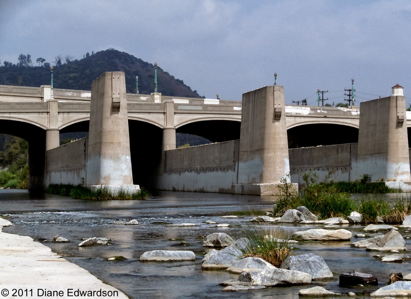
Photo: Diane Edwardson, May 8, 2010.  

The City is proposing another plan reimagining the historic landmark Hyperion Bridge when it goes through an earthquake retrofit.  

Proposal 1A  leaves 2 lanes of vehicle traffic in both directions, but puts pedestrians in direct conflict with bicyclists on 8' wide sidewalks.  Expect lots of blowback from the bike & pedestrian lobbies.  Considering they can't share a 12' wide path in Elysian Valley - this will be a huge sticking point.  

Lots of Red Car Property neighbors have asked me what can be done to alleviate traffic in the area - particularly when it comes to losing car lanes to bike lanes.  If you care one way or another, pay attention & speak up to your City Councilmembers now.  

See all 3 plans: The Eastsider

Wednesday, December 3, 2014

Glendale Blvd & Riverside Drive: 1952 Mudslide *& Rainfall Totals Since Monday

Photo: Unidentified Photographer, Los Angeles Herald Examiner, January 18, 1952 (USC Digital Archives).   The slope on the northwest side of Glendale Blvd. on the Silver Lake side of Riverside Drive has a history of mudslides. (Click on photo to enlarge.)

We'll  update the rainfall totals as soon as our official Corralitas rain gauge reports in.

*Update 12-03-14: Corralitas Drive Rainfall Totals as of 9:30 AM...
Mon, 12-01-14 to Wed, 12-03-14: 1.6"
Season to date: 2.59"

Tuesday, October 1, 2013

2 Freeway: Traffic Back To Normal

Photo: Diane Edwardson, September 30, 2013, 8:50 AM.  The 5 Freeway southbound transition road to the 2 Freeway southbound appears to travel across the rooftops at India Street when seen from the Red Car Property.  (Click on photo to enlarge.)

Suddenly, after months of almost no traffic on either the 2 or 5 Freeways, since the tanker fire in mid-July, morning commute traffic returned to both the 2 & 5 Freeways in the past 2 weeks.  Yesterday, it started at 7:30 AM and continued until 9:30 AM. 

Either the economy is getting better & people are working again, or the City has screwed up the timing on the signals on Glendale Blvd again to make us beg for better public transportation (which won't work if it runs at grade, in traffic) or more housing closer to work.  Here's a thought - build more on the West Side - that's where the jobs are.

Wednesday, September 25, 2013

Hyperion Bridge: 3 Year Rebuild Project
Public Meeting TONIGHT!

Photo: Diane Edwardson, May 8, 2010.  Hyperion Bridge facing Atwater, there's not much of a sidewalk on the Hyperion Bridge, it's barely wide enough for one person to walk.  (Click on photos to enlarge.)

Community meeting sponsored By CalTrans & City Department of Engineering, TONIGHT:

Hyperion Bridge Improvement Project
Wednesday, September 25, 2013
6 - 8 PM
3201 Riverside Drive
Los Angeles, 90027
 

Photo: Diane Edwardson, May 8, 2010.  The sidewalk going up either side of Glendale Blvd from the Hyperion Bridge to Waverly is narrow, but separated from vehicle traffic.  (Reverse angle from the first photo above.)
Photo: Diane Edwardson, May 8, 2010.  A public staircase descends from the northwest side of the Hyperion Bridge to Riverside Drive.  Will the public staircase remain open during construction?

We've included these photos since most people drive through the area, and don't know what features actually exist now. 

Read more about the $50 million makeover: The Eastsider


Tuesday, September 24, 2013

Hyperion Bridge: Reusing Red Car Trolley Footings For New Pedestrian & Bike Bridge*

Photo: Diane Edwardson, April 23, 2011.  One of the mitigations for the Hyperion Bridge reconstruction project is a reuse of the old Red Car Trolley bridge footings in the LA River for a new pedestrian & bike bridge.  (Click on photos to enlarge.)

The Hyperion Bridge complex was built in 1928, before current earthquake standards.  So it's a pretty fair guess that if they're retrofitting the Hyperion Bridge for earthquake safety, there's no way these footings would meet standards for a train bridge today.  The last Red Car Trolley crossed the LA River on the Glendale Line, June 19, 1955.

Photo: Diane Edwardson, April 23, 2011.

There is currently no room for a bike path, nor a real safe sidewalk on the Hyperion Bridge, nor was it in the plans for the updated bridge.  Thankfully, there was no appetite for a road diet to take away lanes of traffic from the bridge (it's been in the works for years).  Yet, it is the only option many students have for walking between Marshall High School & Atwater. It's not a safe way to walk to and from school.

When City Councilmember Mitch O'Farrell was a deputy for (then) Councilmember Eric Garcetti, O'Farrell secured funds from CalTrans to build the pedestrian bike bridge on the Trolley footings. The funds can only be spent on this particular pedestrian bridge project.  

We here at the Corralitas Red Car Blog support this low-impact reuse of an important historic resource. 

This pedestrian/bike bridge should not be confused with the $6 million North Atwater Multi-Modal Bridge just approved last week by City Council.  That one is privately funded & involves equestrian use too.   

It should also not be confused with the historic landmark #770, Red Car Viaduct Footings on the Red Car Property at Fletcher & Riverside Drives.  

There's a big public meeting Wednesday, September 25, 2013 about the Hyperion Bridge Project. 

*Read more on the $50 million dollar Hyperion Bridge makeover: The Eastsider


Monday, September 23, 2013

LA River: Hyperion Bridge Construction Project, Meeting Wednesday, Sept 25, 2013

Photo: Diane Edwardson, January 9, 2013.  Hyperion Bridge from the Atwater side looking toward Griffith Park.  (Click on photos to enlarge.)

CalTrans & the City plan to rebuild the Hyperion Bridge over the 5 Freeway & the LA River.  This has been in the works for years.  The complex of 3 bridges is in the National Register of Historic Places & is an iconic symbol of the LA River.

The project appears to involve widening of the bridge, realigning a 5 Freeway exit, earthquake retrofitting & a pedestrian & bike bridge addition on the old Red Car Trolley bridge footings.  It will take 3+ years & affect a huge swath of Atwater, Los Feliz & Silver Lake as well as all the commuters who will search for new ways to cut through our communities. 

Read the 246 page Environmental Review & comment before October 11 or...

GO TO THE MEETING, FIND OUT WHAT IS GOING ON:
 
Hyperion Bridge Improvement Project
Wednesday, September 25, 2013
6 - 8 PM
3201 Riverside Drive
Los Angeles, 90027

Photo: Diane Edwardson, January 9, 2013.  The plan calls for a pedestrian & bike bridge constructed on the old footings for the Red Car Trolley Bridge adjacent to the Hyperion Bridge.  (We've advocated for this as far back as 2001.) 

Click here for all our Hyperion Bridge posts.


Sunday, July 14, 2013

Riverside Dr, Fletcher Dr, Allesandro St, Glendale Blvd: Expect Gridlock & Attempts At Cut-Through Traffic On All Our Neighborhood Streets

Photo: Diane Edwardson, July 13, 2013. During Saturday's tanker fire road closures, despite clearly marked "Not A Through Street Signs" (like this one at Rosebud Ave at Allesandro Street), countless drivers attempted to cut through, only to find themselves on the winding hillside street of Corralitas Drive, from which there is no easy turn around.(Click on photos to enlarge.)

CalTrans announced Freeway closures will continue through at least Tuesday.  Read more: The Eastsider
Photo: Diane Edwardson, July 13, 2013.  Traffic mayhem ensues when drivers attempt to make u-turns, left turns & right turns, all at once, each hoping they'll find a way through on our hillside streets, like the photo above (which is looking across Allesandro Street to the other side of Rosebud). It too is not a through street but it lacks a sign.  (Not that the signs actually stopped many drivers.)  

While we chatted on the street, a neighbor & I yelled at drivers to stop & turn around before driving up the hill.  That mostly worked. She turned her hose on a few cars too.  That got their attention. 

Neighbors on Silver Ridge & Lake View report drivers speeding through their streets attempting to cut through the neighborhood Saturday.
Photo: Diane Edwardson, July 13, 2013.  The intersection of the 2 & 5 Freeways is like a roller coaster maze of ramps, seen here from the Semi Tropic Spiritualists' Tract.  

Saturday, I emailed a list of suggestions to City Councilmember Mitch O'Farrell of where to place City traffic officers & barricades (restricting local traffic only on side streets) through our corridor.  I know he also met with all of the involved agencies and leaders from Elysian Valley Sunday.  Let's hope traffic control was one of the topics on the agenda.  Monday sounds like a good day to call in sick.

At least there are no Dodgers home games until July 25th!

Wednesday, June 5, 2013

State Route 2 Freeway Terminus Project: Here We Go Again, Community Meeting Next THURSDAY*, June 13, 2013

Photo: Diane Edwardson, July 1, 2009.  This project has been in the works since Jackie Goldberg was our City Councilmember, the original goal was to remove the flyover ramp altogether to improve safety. (Click on photo to enlarge.)

June 13, 2013, Metro & CalTrans will hold a community meeting to update us on the status of the 2 Freeway Terminus Redesign.  The email notice they sent out 2 days ago said nothing of the sound walls they intend to build as a part of the project on Allesandro Street between Oak Glen & Rosebud Ave.  However, we will highlight the sound wall issue over the next week since we've photographed the neighborhood extensively through the years. 

State Route 2 Freeway Terminus Redesign Update
 
Thursday, June 13, 2013*
6 - 8 PM
 
2414 Mayberry St
Silver Lake , 90026
info: (213) 922-3010
 
 
Handy links:
All our sound wall related posts

*Correction: An earlier version had the day listed as Wednesday June 13, the date is correct, the day has been corrected to THURSDAY June 13, 2013. 
 

Wednesday, May 8, 2013

Ralph's: Coming Soon, Whole Foods, Higher Prices, More Gentrification

Photo: Diane Edwardson, 2004.  Since the shopping center housing Ralph's started kicking out their tenants last year, there's been a lot more room in their parking lot.  (Click on photo to enlarge.)

After much speculation, The Eastsider broke the news today, Whole Foods is moving into the Ralph's space on Glendale Blvd. 

Wednesday, January 30, 2013

Fletcher Drive & Glendale Blvd: 1927

Photo: Los Angeles City Engineering Notebook V28-209, AAA of Southern California Archive, USC Digital Archive.  1928.  Looking down Fletcher toward Riverside Drive.  (Click on photo to enlarge.)
 
In order for the City to pave Fletcher in 1927, they had to lower the roadbed and replace the center section of the all wood trestle Pacific Electric Red Car Trolley Viaduct with steel
 
The vacant lot just behind the car on the right is the site where Astro Family Restaurant has been since 1960.  Read more about the history of Astro: The Eastsider

Thursday, October 11, 2012

Glendale Blvd & Bancroft: Probably Not Coast Live Oak, But They Were Significant Trees

Photo: Andrew Sears, October 10, 2012.  One of the 2 larger oak trees cut down last week, with Sears' size 12 foot for scale.  (Click on photos to enlarge.)   
 
We received email from one reader suggesting the oak trees cut down on the vacant lots on Glendale Blvd & Bancroft were not native Coast Live Oak, but might be non-native Cork Oak.  The bark is unusual in that it's spongy and cork-like. 
 
So, we checked CalFlora for oak trees in Los Angeles County.  Looking through the linked photos, it raised further questions.  I asked Sears to shoot some more photos before the lots were completely cleared of tree debris.
 
We apologize for the initial misidentification.  However, when it comes to the potential loss of significantly sized trees, native or non-native, it was better to sound the alarm before the evidence disappeared.
Photo: Andrew Sears, October 10, 2012.  Sears also collected some leaves, acorns, bark and a slice of a branch for further study.  Those are 1" squares on the mat. 
 
We ran these photos and a few others past a local professional landscape designer, a Los Angeles Community Forestry Advisory Committee (CFAC) boardmember, in addition to a neighbor who had a Cork Oak Tree in her yard when she lived in San Diego.  They all agree it might be Cork Oak, a non-native species.  All 3 agree it is not an easy ID and they believe it is not Coast Live Oak.  There are several Cork Oak Trees in the 3900 block of San Rafael in Mt Washington. 

Photo: Andrew Sears, October 10, 2012.  While these trees are not our native protected Coast Live Oak, at least 2 were huge and sprawling, large enough to be considered "significant" trees - trees of more than 8" diameter.  There were also 2 smaller approximately 6" diameter oak trees cut down as well.
 
In City Planning parlance, a "significant" tree only merits replacement on a 1:1 basis with a tree that won't reach this size in our lifetime.  Protected native trees require a higher replacement ratio, but unfortunately, the Protected Native Tree Ordinance doesn't really protect any native trees.  City Planning just uses the replacement ratios and fails to evaluate the cumulative loss of mature native trees in our hillsides.
 
The fact that these trees were cut down prior to a development application being filed for these lots, indicates the developer didn't want to declare plans to remove those trees when they filed plans.  
 
Mature trees add value to homes.  They also reduce air conditioning costs by providing shade.  Depending on the species, they help hold hillsides together in the rain.  The largest of the felled oak trees has been holding the hillside from falling into Glendale Blvd, below, for decades.
 
Eucalyptus, palm trees and timber bamboo do not hold hillsides together, their root structure is not deep, they are extremely combustible and can be a liability for hillside homeowners. 
 
I know at least one architect who goes out of her way to design homes around existing mature trees.  The Silver Lake - Echo Park - Elysian Valley Community Plan discusses the significant urban forest existing in all 3 communities; calls for preservation of mature trees wherever possible.  Neither the City, nor most developers share in our communities' urban forest values. 


Thursday, October 4, 2012

Glendale Blvd & Bancroft: Heritage Coast Live Oaks Cut Down On Vacant Lots, Possibly Without Permits*

CORRECTION 10-11-12: It appears these are not native Coast Live Oak Trees, click here for update.
Photo: Andrew Sears, October 4, 2012.  Sears sent me these photos today.  Yesterday, some huge Coast Live Oaks (a protected native tree) were cut down in vacant lots on the corner of Glendale Blvd & Bancroft.  (Click on photos to enlarge.) 

Photo: Andrew Sears, October 4, 2012.  We don't know whether they trimmed this tree badly on purpose or in stupidity.  Today, it's dangerously balanced and will have to be cut down, or it might fall into Glendale Blvd directly below. 
Photo: Andrew Sears, October 4, 2012.  The Coast Live Oak (the same one from the previous photo) has been holding up the slope above Glendale Blvd for decades.  I think I've even seen it in photos from the 1930s. 
Photo: Andrew Sears, October 4, 2012.  These vacant lots have been on the market for a long time.  We checked ZIMAS and Building & Safety for 2246 W. Bancroft, 2290 N. Glendale, 2286 N. Glendale & 2280 N. Glendale.  No pending development applications nor building or grading permits have even been applied for.
Photo: Andrew Sears, October 4, 2012.  From the sidewalk directly below Glendale Blvd, you get an idea of just how steep that slope really is. 
 
Sears adds there are a lot of smaller Coast Live Oak saplings all over those lots too.  Guess those will all be gone soon too.
 
The City enacted a Protected Native Tree Ordinance #177404 in 2006.  So far, it only seems to make it easier to cut down protected trees by giving developer replacement ratios.  However, in this instance, no permits appear to have been applied for.
 
Stay tuned, we've reported it to the City's Community Forestry Advisory Committee, and I know I've got photos of this site in my archives for comparison. 
 
*UPDATE 10-5-12: Ron Lorenzen, Assistant Chief Forester, Bureau of Street Services, Urban Forestry Division, reports they will investigate.

Saturday, August 4, 2012

Monte Sano: Why Wouldn't You Want To Live Next Door To A Major Construction Site?

Photo: Diane Edwardson, February 9, 2012.  Neighbors of the old Monte Sano Hospital Site at Waverly & Glendale Blvd are learning first hand what excavating more than 46,300 cubic yards of earth means to their health (and wealth as apartment dwellers move out).  (Click on photo to enlarge.) 

Read more: Los Feliz Ledger

See also our posts from:

Wednesday, June 20, 2012

Glendale Blvd: Road Closure Update

Map: DWP.  River Supply Conduit Lower Reach 4 Improvement Project causing traffic and trouble breathing in the neighborhood north of Fletcher on Glendale Blvd.  (Click on image to enlarge.)

DWP sent out an email late Tuesday announcing temporary no right turn from Fletcher onto Glendale Blvd starting Wednesday. Copied directly from the email:

Temporary lane closure of right-turn lane on Fletcher Drive starting June 20: Construction activities will require a temporary closure of the right-turn lane from Fletcher Drive onto Glendale Boulevard, which will be in effect:

June 20-22: 8 am to 5 pm

June 25  at 7 a.m. through June 27 at 6 a.m.

If necessary, the right-turn lane closure may be extended to include:

June 27-29: 7 a.m. to 6 p.m.
June 30: 8 a.m. to 5 p.m.

More Info: www.ladwp.com/RSC4

Related Glendale Blvd traffic news: The Eastsider

Sunday, May 20, 2012

Monte Sano Red Car Stop: Another Staircase You Won't Be Taking On The Big Parade Today

Photo: Paul Ayers, summer 1987.  The Big Parade won't be taking the Monte Sano Red Car Trolley Stop staircase, because it was demolished in 1987 to make way for the RiverGlen Apartments on Riverside Drive, near Glendale Blvd.  (Click on photo to enlarge.)

However, The Big Parade will be highlighting other historic public staircases and sites throughout Silver Lake today.  There's still time to join The Big Parade for a few staircases or a couple hours: http://bigparadela.com/

Follow along with The Big Parade's live Twitter feed:
http://twitter.com/#!/bigparadela

Sunday, April 29, 2012

Silver Lake: Traffic Safety Meeting, Monday April 30, 2012, 4:30 PM *Updated

Photo: Jerome Courshon, April 19, 2012.  DWP construction makes driving and walking in the Glendale Blvd/Rowena corridor more dangerous.  (Click on photo to enlarge.)

*UPDATE, May 1, 2012 Reviews of the meeting:

City Councilmember Tom LaBonge (CD4) will hold a traffic safety meeting, Monday at 4:30 PM. (Really Tom?  4:30PM?  Don't want too many people showing up?)  There have been several pedestrian vs car accidents (with fatalities) in recent weeks in Silver Lake and Echo Park (CD13).

Details directly from the CD4 newsletter below:

Silver Lake Traffic Safety Community Meeting
Monday April 30, 2012

4:30pm-6:00pm
Ivanhoe Elementary School - Auditorium
2828 Herkimer Avenue
Silver Lake, CA 90039


Presentations from
LAPD Traffic
LA Dept. of Transportation
Dept. of Water and Power
Contract Administration
City Planning
and Sliver Lake Neighborhood Council
for more information, contact Mary Rodriguez at
mary.d.rodriguez@lacity.org
or
tracy.james@lacity.org
or call 818.766.7187

Monday, April 23, 2012

Silver Lake Reservoir: Too Bad Most Of The DWP Property Is Off Limits To The Public

Photo: Shawnda Thomas Faveau, March 2, 2008.  Neighbors are looking for new ways to use the Silver Lake Reservoir once it's taken off-line.  (Click on photo to enlarge.)

Read one idea: The Eastsider