Showing posts with label development. Show all posts

Tuesday, January 26, 2016

Citywide: Small Lot Subdivision Ordinance Update, Public Hearing Tonight

Photo: Diane Edwardson, November 6, 2014.  That's the controversial 15-home small lot subdivision in the Semi Tropic Spiritualists' Tract, not an office park in Orange County.  It was built on green field, not in-fill.  (Click on photo to enlarge.)

The City is updating the Small Lot Subdivision Ordinance and design standards for new small lot subdivisions over 20 units.  They're also attempting to incentivize conversion of existing bungalow courts into for sale homes (which is a good thing), rather than tearing them down to build a huge dense development that's out of character with the surrounding neighborhood.

Unfortunately, there's nothing specific to Hillside areas, nor restrictions on green field development.  There is, however, a badly needed requirement for shared trash bins.  The access roads and shared driveways do not appear wide enough for Hillside fire requirements of 20' and should be reconsidered. 

There's also a few references to specific sections of the LA Municipal Code without outlining what they govern.  So we've yet to review all the changes proposed in the ordinance.  As always, the devil is in the details.  Go to the open house and ask questions!

Small Lot Subdivision Ordinance Update 
TONIGHT, January 26, 2016 
Open House: 5:30 - 7 PM
Public Hearing: 7 PM
Grace Simons Lodge
1025 Elysian Park Drive
Elysian Park, 90012

Case #s:
CPC-2015-4499-CA
ENV-2015-4500-CE
Comments in writing will be accepted until February 26, 2016.  See the City Planning website for a host of information.

Wednesday, March 27, 2013

Holyland Exhibition: 1960, Lake View Ave

Photo: Antonio F. Futterer, Holyland Exhibition, 1960.  When you look at the hills between 1934 & 1960, there were not a lot of changes in the hills looking up Lake View Ave from the corner of Allesandro Way.  (Click on photo to enlarge.)

1960 saw the loss of homes and yards throughout the neighborhood for construction of the 2 Freeway. 

This week, we're reviewing photos of the Holyland Exhibition, shot at the corner of Lake View Ave & Allesandro Way to see how the hillsides have changed through the years. 

Tuesday, January 29, 2013

Silver Lake: How Do You Hold A Silver Lake City Council Candidate Forum & NOT Ask A Single Question About The Reservoir?


Photo: Shawnda Thomas Faveau, March 2, 2008.  Silver Lake Reservoir.  (Click on photo to enlarge.)

The Silver Lake Neighborhood Council held a CD13 City Council Candidate Forum last night.  It was the first time all 12 candidates showed up.  However the format precluded fair & open participation by the audience (in which campaign staff and supporters seemed to outnumber actual audience members).   
 
Audience members were asked to submit questions written on forms at the door.  The moderator edited and chose which questions to ask - which seemed to mostly be about neighborhood councils rather than actual issues pressing in Silver Lake.
 
Although the moderator admitted several questions about the Silver Lake Reservoir were submitted, he chose not to read any.  I submitted a very good question about Small Lot Subdivision.  It too was ignored. 
 
As expected, there was no in-depth discussion about any of the big development issues pending in Silver Lake (300 units coming to Sunset Junction, around 100 units in different projects at the 2 Freeway Terminus), or Elysian Park (888 units proposed at Barlow Hospital.)
 
Most of the candidates who haven't spent as much time in the district as others seemed to embrace the murals throughout the community and all eat at the same restaurants. 
 
The election is March 5.  Early voting starts next week. 
 
Keep up with all the latest on The Eastsider's LA City Voter Guide
 
As a 501(c)(3) non-profit organization, Community Residents' Association for Parks cannot endorse a candidate. 


Thursday, November 15, 2012

2 Freeway Corridor: The More Things Change*


Photo: Hunter Terrace - Elysian Gardens real estate brochure, 1922. Shot from Corralitas Drive looking south toward Glendale Blvd. (Click on photos to enlarge.)


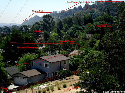
Photo: Diane Edwardson, 2004. Photo matches the one above as well as one posted earlier, shot from Corralitas Drive looking south toward Glendale Blvd. Note the 3 homes circled on Alvarado Ave. have not changed much other than a coating of stucco.

*This post was originally published October 3, 2008.

Saturday, August 11, 2012

Corralitas Drive: Snow Day, 1950

Photo: Smith Family Archives, April 1950.  The current heat wave has me thinking cooler thoughts.  Shot from the top of Corralitas Drive facing the Red Car Trolley tracks between Riverside Place & Lake View Ave. (Click on photo to enlarge.)

Thursday, August 2, 2012

Red Car Property: All Together Now


Photo: Diane Edwardson, 2010.  Red Car Canyon Lake.  (Click on photos to enlarge.)

Monday, July 30, 2012, two neighbors and I, who have led the community on Red Car Property issues since 1992, met with the realtor representing the Red Car Property’s owner. The realtor requested the meeting.

I feel obligated to write this to my neighbors and the community at large, so my actions are not misrepresented to you, potential buyers or politicians. I was required to sign a confidentiality agreement to view the realtor’s sales package, agreeing not share the “concept plans” with the media.

I neither agreed nor disagreed to work with the realtor. The “concept plan” in the realtor’s sales package is a fantasy sales pitch without technical basis in reality. They could have drawn a picture of the property with a 200 story skyscraper surrounded by a lagoon, on paper.

I strongly advised the realtor to speak with my contact at the Trust for Public Land (TPL). If there is a chance for acquisition by a public parks agency, TPL would take the lead in negotiations.

The realtor’s actions seem contrived to panic the neighborhood. We’ve been down this road before with so many developers in the past 20 years.  Please be assured that we will keep working toward acquisition of the Red Car Property as a park.

For more than 30 years, developers have tried and failed to develop the Red Car Property.

We appreciate all the Red Car Property neighbors who have supported our efforts and continue to present a united front through the years. Be assured that we are organizing.  We will continue to fight out of scale development and work to acquire and preserve the Red Car Property as a park. 

Watch this blog for important news.

Sincerely,
Diane Edwardson
22 year resident
20 year community leader

Photo: Diane Edwardson, 2012. City of Los Angeles Cultural Historic Landmark #770; Pacific Electric Red Car Viaduct Footings.

Photo: Diane Edwardson, 2012.  Developers go home!

Tuesday, July 24, 2012

Red Car Property: Legacy Of Failed Development

Excerpted from January 29, 2009 post.
Photo: Diane Edwardson, February 2005. Countless tons of earth were removed for freeway construction in 1960, leaving the Red Car Property slopes to slide in heavy rains. (Click on photo to enlarge.)

Speculators salivate over the large vacant lots in our neighborhood, usually attempting a zone change and hoping to make a quick buck. Developers get a turkey of a property that often ends up being sold at County tax auction because their money runs out. Most of the large lots are where huge quantities of earth was removed for, and dumped after area freeway construction.

The history of failed development on the Red Car Property is long and well documented. More than once, speculators gained approvals for a zone change. Each time the zone change expired unused. Grading was a primary concern. Of course, being in a hole next to the Freeway might have something to do with it too.

A series of Red Car Property owners refused to limit vehicle access to the property resulting in another nuisance. Since the property is used by neighbors as a park, the property has fewer problems with homeless taking up residence.

Tuesday, December 29, 2009

Menlo Property: Public Hearing
January 6, 2010

Photo: Diane Edwardson, November 25, 2009. Plans for the Menlo Property include cutting 68,000 cubic yards of earth from the slope above Riverside Drive north of Fletcher. (Click on photo to enlarge.)

Public Hearing for Menlo Property
City Planning Advisory Agency

Wed., January 6, 2010 (continued from July 22, 2009)
9:30 AM
City Hall room 1020

Case numbers:
ENV-2009-517-MND
VTT-70871-CN
ZA-2009-534-ZV-SPR
2600-2750 Riverside Drive

120 condo units are proposed for the vacant Menlo Property, 2600-2750 Riverside Drive. The discretionary action involves environmental review, a zone variance to allow the 157 existing units and merger and resubdivision of lots for the new condos. Of course, they've been keeping quiet about the acre of encroachments from neighbors on Waverly, which they are allowing to continue, but still counting in their total square footage to gain the maximum number of units.

There is a lot of history to the Menlo Property. It is the poster child for the Legacy of Failed Development in our neighborhood.

See all Menlo Property posts.

Thursday, June 11, 2009

Tonight: 2 Freeway Terminus Redesign Community Workshop

Photo: I have no idea who shot this photo. It's been in my archives and is one of those iconic photos of the Allesandro Cut for the Glendale Line. Today, this same location is the 2 Terminus at Glendale Blvd. If you have photo credit info please contact redcarproperty@gmail.com. (Click on photo to enlarge.)

CalTrans MTA Community Workshop
Thursday, June 11, 2009
6:30-8:30 PM
Barlow Hospital, Williams Hall (in Elysian Park)
2000 Stadium Way
Los Angeles, CA 90026

Click here for background.

Wednesday, January 28, 2009

Idyllic Open Space Endangered


Photo: Diane Edwardson, 2004. Native California black walnut woodland thrives in the Semi Tropic Spiritualists' Tract. (Click on photo to enlarge.)

Just because the City's Grading Dept. approves a plan, does not make it an environmentally sound plan.

The plateau (above photo) along with the downslope (to the right in the photo) containing California black walnut woodland within the Semi Tropic Spiritualists' Tract will be eradicated if a developer's plan to subdivide and sell a 16-lot subdivision (15 homes and one "open space lot") gains final approval by the City Council.

The developer led the community to believe we would be gaining the upper plateau as open space, accessible to the public. However, the developer's grading plan calls for the removal of the entire upper plateau and slope below containing a thriving California black walnut woodland.

Community leaders reluctantly leaned toward the compromise, until they learned (after the close of public comment in December 2007) the slope and plateau would be removed and compacted 2:1, creating a steep, inaccessible slope. Native trees do not grow in compacted slopes. Plus, removal of the plateau would result in no functional park space.

While the developer maintained he would landscape the "open space lot," it is unlikely much would grow on the site. (But then, the developer is not going to build anything; just subdivide and sell.) For an example of a compacted 2:1 slope, see the Menlo Property on Riverside Drive north of Fletcher (the vacant lot between Home Restaurant and the River Glen Apartments).

Tuesday, January 27, 2009

Semi Tropic Hell


Photo: Diane Edwardson. Future site for 15 homes?
(Click on photo to enlarge.)

A developer wants subdivide and sell the Semi Tropic Spiritualists' Tract 3-acre site as a 16-lot subdivision. If approved, almost all of the trees will be cut down and the entire hillside site graded. The "open space lot," lot 16, would be graded and compacted into a 2:1, non-functional slope, even though the developer only plans for homes on the lower portion of the site.

The neighbors learned of the developer's grading plan AFTER the close of public comment in December 2007. The grading plan was approved by the Grading Division of Los Angeles Dept. of Building & Safety in March 2007, but the approval letter was missing from the City Planning case file until a neighbor provided it to the City Planning staff (per staff request) in February 2008.

The public was denied due process since the most important environmental factors, the grading and tree loss, were not made public nor evaluated properly under CEQA.

While anything built on the site should be safe and to current grading standards, the neighbors think the loss of so many mature and native trees combined with a complete reshaping of the hillside is too high a price to pay, especially since the developer has no intention of actually building the site himself.

The neighbors will make their appeal to the City Council Planning & Land Use Management Committee next week:

PLUM
Tues Feb 3, 2009
2pm

City Hall, Room 350

City Council File: CF-09-0082
APCE 2006-8787-ZC
VTT 62900-SL-2A
CD13

Friday, January 16, 2009

Stalked at Tree #50


Photos: Diane Edwardson, January 14, 2009. Tree #50 on the Red Car Property
and Adelbert Ave. (Click on photos to enlarge.)

While walking the Red Car Property, I noticed some newish metal tags on a few of the trees at the Adelbert end. Admittedly, I've not walked the property much lately, so I am not sure when the tags appeared. The neighborhood guard dog (above right) did not appreciate my interest in the tagged trees. Tree #50 (written in marker over an engraved #425, see below) is a significant eucalyptus tree.

Thursday, January 1, 2009

Backing into the New Year


Photos: Kolts, 1937. Nancy Kolts at 2598 Corralitas Drive.
(Click on photo to enlarge.)

There were once giant power line towers crossing the Red Car Property, Corralitas and Allesandro to the Semi Tropic Spiritualists' Tract. The house in the background burned down in a fire in 1980. Photo courtesy Pat Kolts.

Friday, December 5, 2008

1922, Coolidge Ave., "Elysian Gardens"


Unknown Photographer, 1922 Elysian Gardens - Hunter Terrace real estate brochure. House on Coolidge Ave. at Ripple St. (Click on image to enlarge.)


Photo: Diane Edwardson, 2008. The same house at the corner of Coolidge Ave. and Ripple St. (Click on photo to enlarge.)

"Elysian Gardens" was the tract on the LA River side of Riverside Drive, within the community of Elysian Valley. Unfortunately, the trees obscure the unique roofline that proves the house above is the same house in the 1922 brochure. Today, the 2 & 5 Freeways run through its backyard.

Monday, December 1, 2008

1922, Riverside Drive


Unknown photographer, 1922 Elysian Gardens - Hunter Terrace real estate brochure.
(Click on image to enlarge.)
"All the beauty of mountain colors; the healthfulness of mountain air..." proclaimed the 1922 real estate brochure. Today, the same location on Riverside Drive (center photo above) sports an array of overpasses for the 2 and 5 Freeways adjacent to Allesandro Elementary School (below). The air is no longer healthful, so we do value our trees.

Photo: Diane Edwardson, 2008. Riverside Drive from the main entrance to Allesandro Elementary School, facing east toward Allesandro Ave. (Click on photo to enlarge.)

Friday, November 28, 2008

1922: Allesandro Elementary School from Corralitas Drive


Unknown photographer, 1922 Hunter Terrace real estate brochure.
(Click on photo to enlarge.)


Photo: Diane Edwardson, 2008. (Click on photo to enlarge.)

Of course, the 1922 brochure does not mention the 800 sq ft lots that were closest to the Red Car tracks, which were typical of neighborhoods immediately surrounding the trolley lines throughout Los Angeles. The lots closest to the tracks were small and more affordable. As you moved away from the tracks, the lots and homes got larger.

Most of the neighborhoods closest to the Red Car tracks were destroyed for freeway construction. Stroll down Riverside Place for a walk through the past. Many of the original 500 sq. ft. homes on 800 sq. ft. lots still survive.

Thursday, November 27, 2008

Selling Points: Nearby Trolleys, School & El Nino


Unknown photographer, 1922 Elysian Gardens - Hunter Terrace real estate brochure. (Click on image to enlarge.)

"Last December, shortly after the heaviest rainfall in 32 years, automobiles were driven over every lot in Elysian Gardens." Considering the LA River was prone to flooding prior to being encased in cement, this was an important disclosure.

Wednesday, November 26, 2008

Riverside Terrace & The Corralitas Hillside


Photo: Unknown photographer, 1922 Elysian Gardens - Hunter Terrace real estate brochure. (Click on photo to enlarge.)


Photo: Diane Edwardson, 2008. Matches photo above from slightly higher ground. (Click on photo to enlarge.)

The hills to the left of Elysian Park in the current photo, are the hills in the background (left) of the 1922 brochure photo above. Today, houses, freeways and trees obscure the exact matching views. Differences in lenses, format, lighting and atmospheric conditions make the hills look closer in the earlier photo. Similarly, neighbors often ponder how some days the San Gabriel Mountains appear taller than usual.

Tuesday, November 25, 2008

1922 Real Estate Brochure


Photo: Unknown photographer, 1922. (Click on image to enlarge.)

Over the next week, we'll look at the 1922 Elysian Gardens - Hunter Terrace real estate brochure and attempt to match as many of the photos with current views as possible. Earlier postings showed images of the 2 Freeway corridor and a map. Can you guess the location of the photo above? (Answer tomorrow.)

Hunter Terrace was named for the former Asa Hunter Estate. The 1912 map, below, shows the Hunters owning large tracts of land on both sides of "Los Felis Road," which later became Riverside Drive. The map from the brochure indicates Elysian Gardens as the area between the Los Angeles River and Los Felis Road: the neighborhood is also know as Elysian Valley and Frogtown.


Map: Plate 42, Baist's Atlas, Surveys of Los Angeles, G.W. Baist, 1912. (Click on map to enlarge.)

Tuesday, November 11, 2008

2 Freeway Terminus EIR Release Delayed


Photo: Diane Edwardson, 2008. Typical morning commute traffic on the 2 Freeway shot from the Corralitas Staircase. (Click on photo to enlarge.)

Judy Raskin, chair of Echo Park Community Action Committee, reports release of the Draft Environmental Impact Report for the 2 Freeway Terminus Redesign is delayed until at least mid-December due to coordination efforts between CalTrans and MTA.

When the draft is released, the public will have 45 days to review and comment. Since the current schedule would release the draft EIR in the middle of the holidays, Echo Park CAC requested the release date be further delayed until January 2009. The public should not have to review these plans during the holiday season.

The MTA reviewed the design alternatives at last week's Echo Park Improvement Association meeting. According to Raskin, the MTA is creating confusion by labeling of one of the design alternatives as the "Locally Preferred Alternative." Raskin continues, "It does not mean the community (locally) prefers the alternative. Keep this in mind when the reports are issued. The Echo Park CAC has always supported the design now designated Alternative D."

The Silver Lake and Echo Park communities overwhelming supported Alternative D throughout the public scoping process.